Marine Transportation
Information and Schedule
Woodfibre LNG is committed to providing information on our marine transportation activities in Howe Sound, including providing cargo vessel, passenger ferry, barge and water taxi schedules, as well as safety and navigation considerations.
Route Information
The vessel schedules below provide an estimated date and time of departure and arrival of vessels during construction. The Project Access Routes map shows marine access routes that will be used for marine transportation during construction including:
- Squamish Harbour Route: Passage through Mamquam Blind Channel and Squamish Harbour to Woodfibre LNG.
- Darrell Bay Route: Passage from Darrell Bay through Squamish Harbour to Woodfibre LNG.
- Southern Howe Sound Route: Originating in the Port of Vancouver and Horseshoe Bay with passage though Howe Sound, including Queen Charlotte Channel, Passage Island between Cowan and Point Atkinson to Pam Rocks, Montagu Channel east of Anvil Island, continuing northeast of the Defence Islands to Woodfibre LNG.
Weekly Arrivals and Departures
| Vessel Type | Project Activity | Client | Operator | Hours | Route |
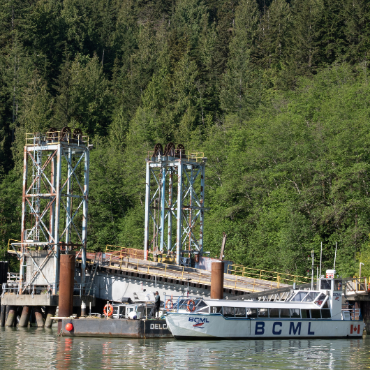
| Passenger Vessel (12 person capacity) | Personnel transportation | WLNG | BCML | Daily between 5:30am and 6:00pm | Squamish Harbour Route |
| Passenger Vessel (50 person capacity) | Personnel transportation | WLNG | BCML | Daily between 5:30am and 8:00pm | Darrell Bay Route |
| Passenger Vessel (100 person capacity) | Personnel transportation | WLNG | MDR | Tuesday, Wednesday, Thursday at 6:40am, 9:30am, 12:20pm and 3:45pm | Vancouver Harbour Route |
| Passenger Vessel (49 person capacity) | Personnel transportation | WLNG | MDR | Tuesday, Wednesday, Thursday at 11:00am and 1:15pm | Horseshoe Bay Route |
| Water taxi (11 person capacity) | Personnel transportation | FortisBC | FortisBC/SMJV/FKM | Daily between 6:30am and 5:00pm | Squamish Harbour Route |
| Fuel Barge | Materials & equipment transport | WLNG | Parkland | Weekly on Wednesday | Vancouver Harbour Route |
| Tug / Barge | Materials & equipment transport | WLNG | LBLNG | Monday, Wednesday, Friday | Vancouver Harbour Route |
| Tug / Barge | Materials & equipment transport | WLNG | FortisBC/SMJV/FKM | Monday and Saturday | Vancouver Harbour Route |
| Tug / Barge | Materials & equipment transport | WLNG | MDR-Pomerleau | Thursday and Sunday | Vancouver Harbour Route |
| Tug / Barge | Materials & equipment transport | WLNG | Fortis/PCL | Every Tuesday and 2nd Thursday of every month | Vancouver Harbour Route |
| Tug / Barge | Materials & equipment transport | WLNG | Kiewit | Thursday | Vancouver Harbour Route |
Marine Safety Considerations
Marine Safety Zone (MSZ)
A Marine Safety Zone (MSZ) has been established at the Project site to ensure public safety and site security during Project construction effective until January 31, 2027.
Multiple vessels, barges and equipment (both on-shore and in-water) will be conducting activities to support the construction of the Woodfibre LNG facility. Activities may include piling, blasting, vessel maneuvering and anchoring, loading and unloading of equipment, machinery, materials and people.
- The MSZ will be controlled by Woodfibre LNG personnel and non-project vessels are asked to keep a safe distance from the area.
- Operations will occur 7 days a week and will occur 24 hours a day during some periods.
- All marine vessels will be monitoring Channel 16; water taxis utilize Channel 8; Tugs utilize channel 9.
Location of Activity:
Centre of activities is at approximately 49° 39.9’N 123° 15.3’W. Marine construction and related activities will take place throughout the area – generally along approximately 1500 metres of shoreline from 49° 39.50’N 123° 15.50’W to 49° 40.12’N 123° 14.67’W, with associated marine traffic to extend outwards.
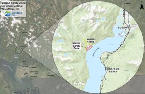
View map in full here.
Project Vessel Operation
Project-related vessels and other vessels operating are required to maintain strict adherence to Canadian regulatory requirements, including but not limited to the Collision Regulations under the Canada Shipping Act, 2001. This is a key regulatory requirement to ensure the safe navigation of all vessels. Each Project-related vessel will be controlled by its own captain and crew who have discretion to maneuver the vessel in the safest way possible.
Canadian Coast Guard Notice to Mariners (NOTMAR) and Navigational Warnings (NAVWARN)
Woodfibre LNG will notify the Canadian Coast Guard of activities that may result in navigational obstructions. This information will allow the Canadian Coast Guard to issue Notice to Mariners (NOTMAR) and Navigational Warnings (NAVWARN) as they deem appropriate.
Navigational Aids
Project-related vessels will use existing aids to navigate when transiting marine access routes. The Project will require approval and or a notice of works under the Canadian Navigable Waters Act for all components of the Project in navigable water.
Navigational Charts
Woodfibre LNG will notify the Canadian Hydrographic Service when it has completed its marine works. This information will allow the Canadian Hydrographic Service to update navigational charts and other nautical publications as they deem appropriate.
BC Ferries
Woodfibre LNG will notify BC Ferries of the intended Project marine access routes prior to commencing construction. Project vessel schedules may be altered if potential interferences are identified between BC Ferries and the Project.
Resources
Vessels can be tracked through the following websites:
- Pacific Pilotage Authority (vessels carrying a BC Coast Pilot)
- MarineTraffic (vessels identified through publicly available AIS-receiving stations)
Mariners can contact the Canadian Coast Guard’s Marine Communications and Traffic Services (MCTS) Victoria on marine VHF Radio or by telephone.